
This is the "jumping off "
point for your research. On the following pages are pictures of the surface of Mars,
geologists call them "Plates". You and your team must identify the landslides
that you find according to what the
S.A.M. wants.
Move the cursor over the area which you believe to be a landslide and click. You will be
rewarded if you are correct but, if you are wrong you will be sent to review the
tutorial on landslides.
The following plates are of areas close to the Association's major
population centers and not all of them have landslides. Have a pencil and paper ready and
keep a record of each Plate you vist. Make sure that you record the number and location of
each slide. See below for Location Guide.
Good luck. Remember the Settlement Association is counting on you.
| Plate I | Plate IV | Plate VII | Plate X | Plate XIII |
| Plate II | Plate V | Plate VIII | Plate XI | Plate XIV |
| Plate III | Plate VI | Plate IX | Plate XII | Plate XV |
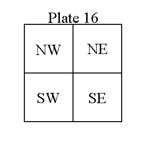
Location Guide
To locate landforms on a map or a photo, geologist subdivide the photo into four equal quadrants (smaller areas). They label these as Northeast (upper right area), Southeast (lower right area), Southwest (lower left area) and Northwest (upper left area). For each Plate (photo) you examine draw a rectangle, subdivide it into the quadrants and label them NE, SE, SW and NW. When you find a landslide, title your rectangle Plate __ and then determine which area the slide is in, sketch it in and write "LANDSLIDE"